Post #4 What did I do for this project?

Did you have to do any training before you could participate? Describe that.

This project did not have very much training to do. After you sign up, there is a brief tutorial walking you through what you are supposed to do (basically, click the tag of the desired species on the right, then click on that animal in the thermal image. If you are unsure, use the “unsure” tags and one of the project admins will examine the image). The project also had a “field guide”, which contained examples of the different species as they might appear in thermal images, available while you were examining images to aid in identification.

Share your experiences actually participating in the project – are there things you found particularly interesting about it? Any specific experiences you want to share? Describe what you actually did, and how it went!

I worked on this project on 3/14, 3/19, 3/27, 4/1, 4/2, 4/3, 4/9, 4/10, 4/11, 4/15, 4/16, 4/17, 4/18, 4/22, 4/23, and 4/24. Because the project was entirely computer based, I could work on it whenever I had some free time (usually in the afternoons) and would usually work on it in 10-20 minute increments. My role was pretty straightforward. I would be shown a thermal image taken by a drone flying over a safari park located in the UK. My job was to identify any wildlife shown in the image as a rhino, an antelope, a human, “not sure what kind of animal”, or “not sure if it is an animal” and apply a corresponding tag to the picture. A fully analyzed image might look something like this:
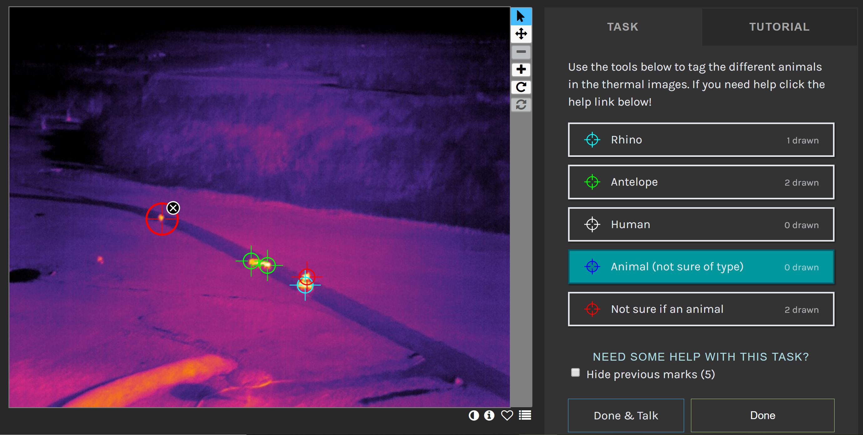
I think my role in the project went well. I definitely found that as I analyzed more images, I spent less time using either of the “not sure” tags. It was also interesting to see the same image multiple times and realize how I might apply slightly different classifications each time based on getting a different look. (I don’t envy people who write image analysis algorithms for a living after doing this.)

Is this a project you’re considering staying with after this course ends? Why or why not?

I could see myself periodically working on this project after the course ends. It does not require a large time commitment, and it is interesting to be working on a project at the relative forefront of the scientific discipline. In addition, the researchers running the project have announced plans to add images of other types of wildlife in the coming months, so I would be excited to work on classifying those animals.

Post #3 What kind of outreach does the project have?

What is the user experience like? How is this project advertised to the public? Could that be improved?

The Zooniverse interface for this project is fairly straightforward and easy to use. While there is a “Talk” thread for discussing difficult to classify (usually blurry or crowded) images, it is usually low activity. As a result, there is limited interaction between users or between users and the researchers. As for public advertisement, the project does not seem to be advertised beyond the Zooniverse page. However, I think that is intentional as the end goal of the project appears to be more research based, and the project on Zooniverse is only for the purpose of helping train the algorithm during development

Do you think this project has a positive impact on conservation in general (from an outreach/educational perspective)? Could this be improved?

I think this project has a strong positive impact on conservation, but not necessarily from an outreach/educational perspective. The goal of this project is training a machine learning algorithm to analyze thermal images from drones to detect conservation threats such as poachers. This project may be useful in providing data for conservation outreach or education programs, but the intent of the project itself is not outreach.

Do you think there are goals for this project beyond the stated scientific goals? Is the focus more on collecting scientific data, or engaging the public? Do you think that there is anything problematic about their focus?

The researchers leading the project have already announced plans to expand the project beyond wildlife conservation into other forms of environmental protection. This expansion includes goals such as improved detection of underground peat fires through thermal imaging and using drone-mounted spectrographs to detect environmental pollution. The project as a whole seems far more focused on collecting scientific data, which I do not see as problematic, since presumably the collected data will be used to promote conservation measures.

In general, in terms of the outreach and educational value of this project, are there things that you’d change if you were in charge?

If I was in charge of the project, the biggest change I would make is to provide information about how the collected data will be used in conservation. For example, if the goal is to detect poachers, will data from this project be used to help park rangers develop better patrol routes to prevent poaching? Or to identify poaching camps to allow for law enforcement action? To be fair to the researchers leading the project, the project was only started about two years ago, and much of that time has been spent developing the image analysis system and getting proof of concept.

Post #2 How does this work?

What happens to the data? How is it used? Are there any missed opportunities?

The data collected in this project is being used to train a machine learning algorithm to automatically analyze thermal images and collect relevant data on wildlife. Each image is viewed by multiple volunteers to ensure tags are accurate, and once an image has been sufficiently viewed and tagged with concurring tags, it will be fed into the machine learning algorithm. I don’t see any obvious missed opportunities for the data usage, as the researchers are already planning to expand how the data is used as the algorithm is refined.

Are there aspects of the project that you think could be problematic or would change?

As we have discussed in class, the use of drones always brings the risk of disturbing wildlife, whether through noise, physical crashes, or any other means you could think of. In an FAQ on the Zooniverse page for this project, the researchers acknowledge this risk, but state that most animals are only bothered the first time they see or hear the drone and quickly adapt when they realize the drone does not pose a threat. In addition, the researchers highlight that most responses they have seen are relatively minor (elephants briefly clumping up, monkeys temporarily dropping down to lower branches).

Are there aspects of the project that you think are innovative or clever?

I think the most innovative aspect is the use of machine learning algorithms developed for astrophysics in a conservation setting. Thermal imagery has long been used in conservation to detect species at night or in heavily forested areas, but the addition of automated image analysis will allow for closer to real-time views of wildlife. These real-time views can be particularly helpful when it comes to detecting poaching. To me, this project is a great example of how very different branches of science can work together to produce important results.

How have the results been shared (or will they be shared)? Is the focus of the project on communicating with other scientists? The public? Both?

This project was started in early 2017, with the publication of a proof of concept paper. Since then, there have only been a couple of papers published (mostly of pilot studies or optimizations of the technology), as much of the work has presumably focused on getting the project up and running. From what I can gather on the project’s website, the focus will be using this image analysis to provide relevant information to both researchers and park rangers to allow for maximum protection of the animals. There does not presently seem to be a significant focus on outreach to the general public by the researchers directly.

Sources:

Longmore, S. N., et al. “Adapting astronomical source detection software to help detect animals in thermal images obtained by unmanned aerial systems.” International Journal of Remote Sensing38.8-10 (2017): 2623-2638.
Burke, Claire, et al. “Optimizing observing strategies for monitoring animals using drone-mounted thermal infrared cameras.” International Journal of Remote Sensing 40.2 (2019): 439-467.
Burke, Claire, et al. “Addressing environmental and atmospheric challenges for capturing high-precision thermal infrared data in the field of astro-ecology.” High Energy, Optical, and Infrared Detectors for Astronomy VIII. Vol. 10709. International Society for Optics and Photonics, 2018.

Post #1 Astro-Ecology: An Introduction

Why does this project exist?

Many endangered species live in remote, difficult to reach areas. As such, it can be difficult to reach them when members of the species are injured or become ill. This remoteness can also make it easier for poachers to hunt species without being detected by the authorities. This project aims to use thermal image analysis techniques developed for astrophysics to identify species and detect injury, illness, or poaching via a network of drones. This information can be gathered and used to direct rescue or enforcement efforts.

Who is running this project?

This project is run through the Astrophysics Research Institute at Liverpool John Moores University. The project’s website can be found here.

What am I doing in this project?

The net goal of this research project is to use machine learning to analyze thermal images taken by a fleet of drones. However, in order to train the machine learning algorithm, it needs to be given images where different species have been correctly identified. My role is looking at drone images and tagging the different species present in the image. Each image is viewed by a plurality of participants to ensure accurate tagging.

What are the conservation threats this project aims to address?

We’ve learned in class that a key part of conservation efforts is surveying an ecosystem and learning what species live there and how they are distributed. This project aims to reduce the costs and increase the efficiency of those surveys by automating much of the process, allowing researchers to analyze a greater area (Longmore et al. 2017).

One of the key threats this project aims to address is poaching. Traditional efforts to detect poaching in real-time have been limited by factors such as geographic and optical range of the detector, cost of operating the detector, or inability to disguise the detector well enough to prevent discovery by the poachers (Kamminga et al. 2018). This project aims to address the threat through the use of infrared sensing drones. Since most poaching occurs at night, these drones are still able to see poachers while remaining at a distance of several hundred feet to prevent risk of poachers destroying the drones (Burke et al. 2018). This system enables real time detection of poachers with limited downsides. In addition there is ongoing research to optimize the drones’ effectiveness.

Sources:

Longmore, S. N., et al. “Adapting astronomical source detection software to help detect animals in thermal images obtained by unmanned aerial systems.” International Journal of Remote Sensing38.8-10 (2017): 2623-2638.
Kamminga, Jacob, et al. “Poaching detection technologies—a survey.” Sensors 18.5 (2018): 1474.
Burke, Claire, et al. “Addressing environmental and atmospheric challenges for capturing high-precision thermal infrared data in the field of astro-ecology.” High Energy, Optical, and Infrared Detectors for Astronomy VIII. Vol. 10709. International Society for Optics and Photonics, 2018.